Site Maps
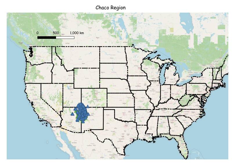
There are 230 site outside the canyon listed in the Chaco Research Archives Outlier Database. I have mapped 118.plus 30 in the canyon.
The Outliers LIDAR was mapped usinng data (las files) from the USGS National map website, while the sites in Chaco Canyon were mapped using data from the Open Topography website. Site configurations were derived by carefully georeferencing various archeologial layout maps. I tried to give credit to the source on each map. Many of the sites in the Chaco Outlier Database, part of the Chaco Research Archives, did not leave a footprint on the LIDAR and were not included here. With the help of old friends John Stein and Rory Gauhier I think I got most of the known major Chaco affiliated sites. What exactly are Chaco sites will be argued about for years to come. I am not an Archaologist, I am a retired Licenced surveyor. But I grew up in New Mexico, and spent my whole adult life in Northwestern New Mexico. For information on each site look at Chaco Research Archives, Chaco Outlier Database, or Google the name of the site.
The following is a surveyors opinion of the Chaco North Road.
Reconsidering the Chaco North Road: Alignment, Survey, and Late Chacoan Landscape Design
Abstract
The Chaco North Road has traditionally been described as a prehistoric transportation route extending north from Chaco Canyon. Based on field survey, GPS documentation, LiDAR analysis, and GIS-based alignment modeling conducted in 2008–2009, we argue that this interpretation is misleading. Instead, the North Road is better understood as a set of deliberate linear alignments linking Chaco Canyon to Aztec Ruins and related sites. These alignments are exceptionally straight, lightly expressed on the ground, and closely associated with late Chacoan architecture dating to around AD 1100. The evidence suggests a single, coordinated construction episode rather than a maintained road system. While the purpose of these alignments remains uncertain, their form and context argue strongly against transportation or economic use.
Introduction
Chaco Canyon occupies a central place in the archaeology of the American Southwest. Between roughly AD 850 and 1150, it served as the core of a far-reaching system of great houses, outlying communities, and engineered landscapes. Among the most puzzling elements of this system are the so-called Chacoan roads—broad, linear features that extend outward from the canyon across the San Juan Basin.
The North Road is the most prominent of these features. It is long, remarkably straight, and leads toward Aztec Ruins, another major Chacoan center. Despite decades of study, the function of the North Road has remained unresolved. Traditional interpretations have emphasized transportation, communication, or economic integration, yet these explanations struggle to account for the road’s extreme straightness, minimal ground expression, and lack of clear evidence for sustained use.
In 2008 and 2009, we undertook a focused effort to document the North Road using modern survey and GIS techniques. At the time, Scott Andrae was a Licensed Professional Surveyor, and John Stein had previously worked on the Bureau of Land Management’s 1983 Chaco Roads Project. Our goal was not to rediscover the road, but to examine its geometry and spatial relationships more closely and to ask whether the feature is best understood as a “road” at all.Methods
Field Survey and GPS Documentation
We documented swales, architectural features, and isolated artifacts north of Chaco Canyon, recording latitude and longitude as close as possible to the estimated center of each swale. One observation quickly became clear: north of the canyon, there is no such thing as an isolated artifact. Even a single sherd, when plotted with GPS, consistently fell on or very near one of the identified alignments.
GIS Analysis Using QGIS
All spatial analysis was conducted in QGIS. Field-collected GPS points were imported, reprojected into UTM Zone 13N (NAD83), and examined against Digital Elevation Models, hillshade rasters, and slope models. These datasets allowed subtle topographic features to be visualized more clearly than was possible in the field alone.
LiDAR-derived hillshade proved especially important. Several features, including a swale on the Carson Divide and site BC-27, were not documented with GPS during the original fieldwork but were clearly visible in LiDAR data and fell precisely on projected alignments.
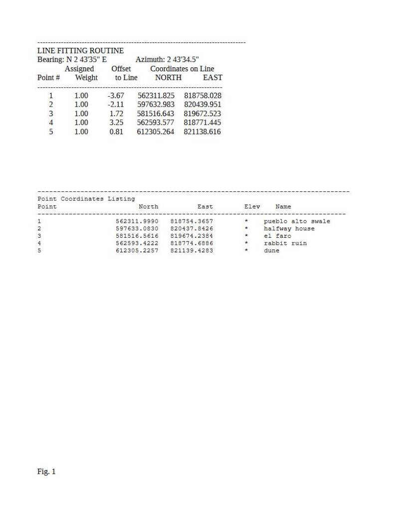
Straight-line connections between selected swales and sites were generated and evaluated for angular consistency over long distances. Given the overall length of the system—approximately 33 miles—even very small deviations are meaningfulThe Chaco–Aztec Alignment
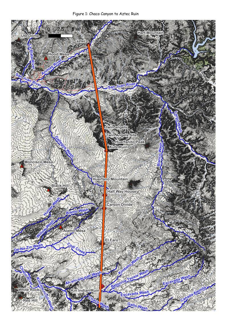
Among the multiple alignments identified, one stands out as the most formalized and consistent. This alignment extends from Chaco Canyon to Aztec Ruins. Although we cannot determine whether the alignment was conceived as leading toward or away from Chaco, we describe it here as beginning in the canyon for clarity.
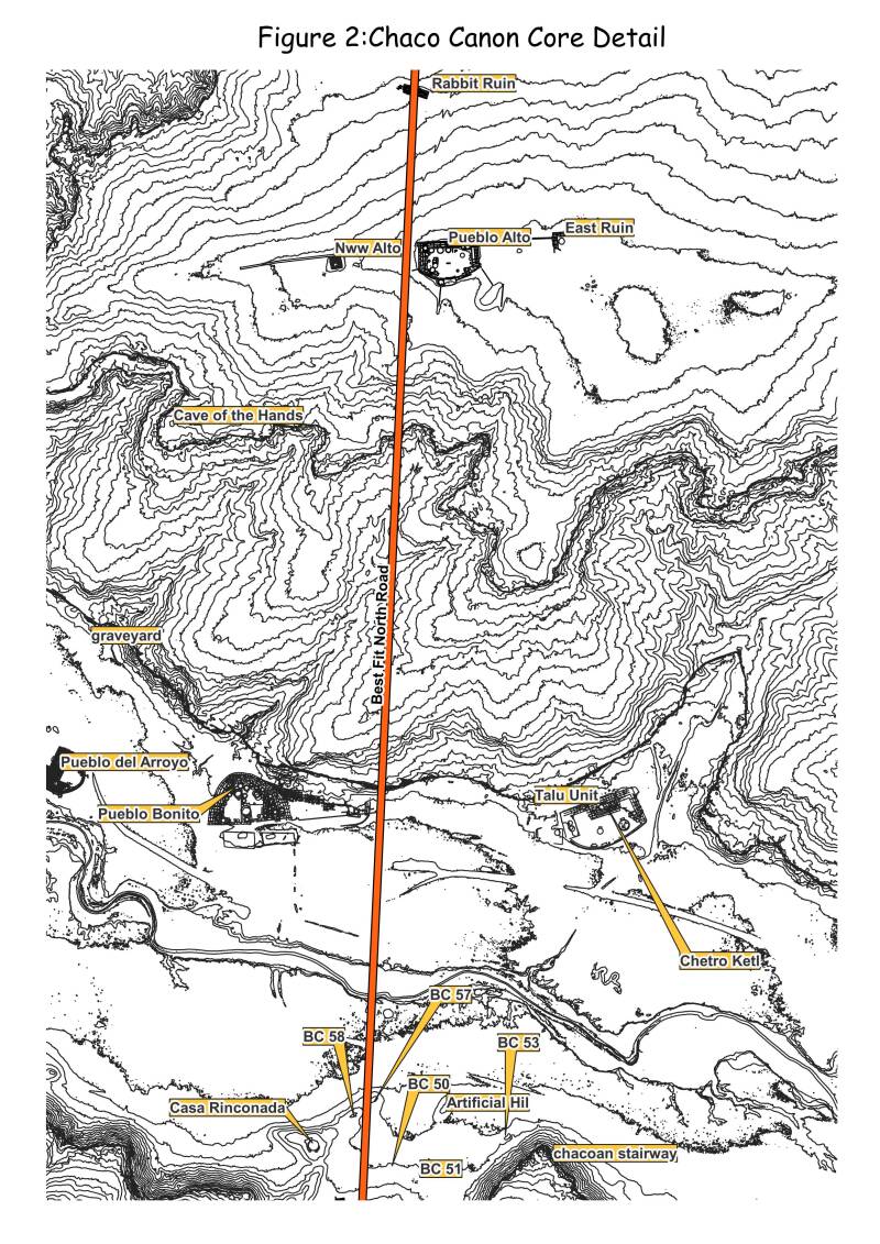
The alignment begins at BC-57, roughly 100 meters east of Casa Rinconada. From there it trends slightly northeast to a swale near the northwest corner of Pueblo Alto, then continues in a straight line to Rabbit Ruin. Rabbit Ruin contains a narrow “alleyway” that may have functioned as a formal entry or exit corridor.
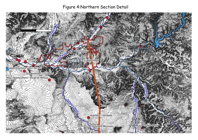
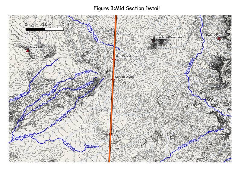
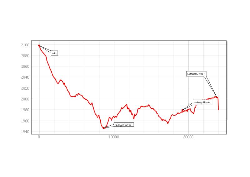
From Rabbit Ruin, the alignment continues directly to El Faro and then to the swale at Halfway House, passing through a swale on the Carson Divide. From Halfway House it proceeds to a ruin and swale just south of the rim of Kutz Canyon, which we refer to as the Dune Ruin. At this location the alignment shifts slightly, forming an angle point. Beyond this point it trends northwest to Angel Peak Ruin and then continues directly to the great kiva at Aztec West.
Visibility and Construction
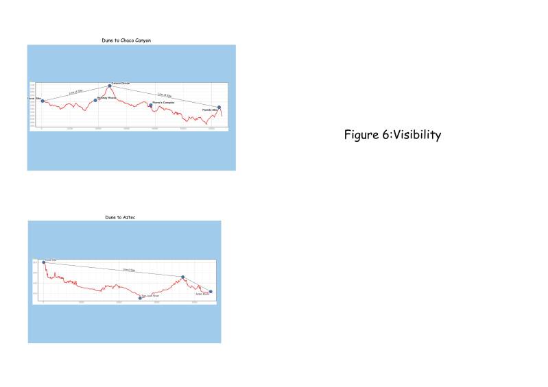
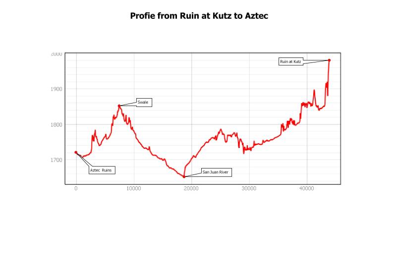
The straightness of this alignment raises an obvious question: how could such long lines be created without modern instruments? One plausible answer comes from basic surveying practice. A technique commonly called “wiggling in” or “bucking in” allows a point to be placed on a straight line by visually centering between two visible endpoints.
Between Chaco Canyon and the Kutz Canyon area, the Carson Divide provides a vantage point from which both ends of the alignment are visible. Similarly, a ridge between the modern towns of Bloomfield and Aztec allows intervisibility between the Kutz Canyon area and Aztec West. From these locations, long lines could be broken into progressively shorter segments while maintaining overall accuracy.
The alignment can be dated indirectly through its associated architecture. Twin Angels, Rabbit Ruin,Halfway House, and Dune Ruin appear to be the most closely related sites, and their construction dates cluster around AD 1100. This places the alignment late in Chacoan history and suggests it was not the result of gradual development over centuries, but rather a single, coordinated effort.
Multiple Alignments and the Corridor
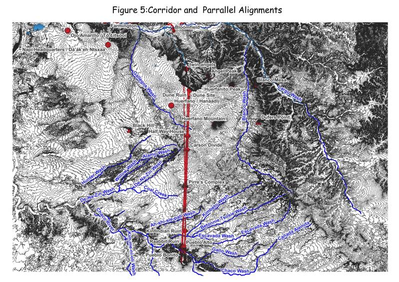
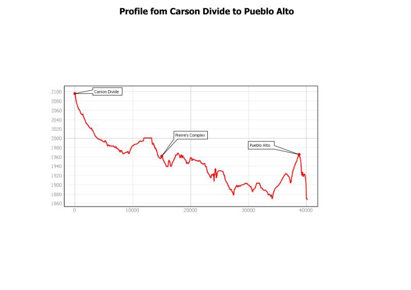
When all documented swales are plotted and treated as straight-line features, multiple alignments appear within a broader corridor north of Chaco Canyon. This corridor is hourglass-shaped, narrowing near the Pierre’s Complex and widening to roughly a mile at both the northern and southern ends.
This geometry helps explain reports of “parallel roads” north of the Pierre’s Complex. Over a distance of more than 30 miles, slight convergence or divergence would appear parallel when examined locally.
Connections to Chaco Canyon
At the northern end, modern disturbance limits interpretation. At the southern end, however, the alignments consistently intersect significant locations. Some terminate at Pueblo Bonito, others descend ramps near Chetro Ketl, and others intersect small sites at the base of the north canyon cliffs. These repeated connections argue strongly against coincidence.
Comparison with the BLM Roads Project
The BLM Chaco Roads Project provided essential documentation of linear features using aerial photography and field survey. In that work, these features were generally interpreted as roads forming part of a transportation or communication system.
Our alignment model does not contradict the BLM observations but offers a different explanation. Features interpreted as parallel roads resolve into points along straight-line geometries when examined spatially. Their light ground expression and apparent lack of maintenance are difficult to reconcile with long-term infrastructure.
The late dating of associated sites further suggests that these alignments were created during a specific episode rather than maintained over generations. Interpreting them as alignments rather than roads resolves many of the problems inherent in transportation-based explanations and shifts attention toward intentional landscape design.
Interpretation
The evidence strongly suggests that the North Road alignments were created during a single event and were not maintained. Transportation of goods is an unlikely explanation. Without beasts of burden or wheeled vehicles, transport would have been limited to what individuals could carry, at great cost and little return.
What these alignments were for remains unknown. What is clear is what they were not: they were not practical roads. Their scale, precision, and targeting of important places indicate intentional design. Large-scale linear geometry may have provided a way to formalize direction, order, or shared meaning across the landscape without requiring ongoing use.
Conclusion
Reframing the Chaco North Road as a system of alignments rather than roads resolves long-standing interpretive problems. The Chaco–Aztec alignment reflects deliberate geometry, late construction, and strong architectural associations, yet shows no evidence for sustained use. These features represent a monumental act of landscape organization whose purpose remains uncertain, but whose execution reflects sophisticated spatial knowledge and coordinated social action.
Bibliography
Cordell, Linda S., and Maxine E. McBrinn
2012 Archaeology of the Southwest. Left Coast Press, Walnut Creek, California.
Kincaid, Chris
1983 Chaco Roads Project Phase I: A Reappraisal of Prehistoric Roads in the San Juan Basin. Bureau of Land Management, Albuquerque District.
Lekson, Stephen H.
1999 The Chaco Meridian: Centers of Political Power in the Ancient Southwest. AltaMira Press, Walnut Creek, California.
Marshall, Michael P., John R. Stein, Richard C. Loose, and Judith E. Novotny
1979 Anasazi Communities of the San Juan Basin. National Park Service, Santa Fe.
Sofaer, Anna, Michael P. Marshall, and Rolf M. Sinclair
1989 The Great North Road: A Cosmographic Expression of the Chaco Culture of New Mexico. In World Archaeoastronomy, edited by A. F. Aveni, pp. 365–376. Cambridge University Press.
Stein, John R.
1983 Field Survey and Documentation Methods in the Chaco Roads Project. In Chaco Roads Project Phase I, edited by C. Kincaid, pp. 25–54. Bureau of Land Management.
Van Dyke, Ruth M.
2008 The Chaco Experience: Landscape and Ideology at the Center Place. SAR Press, Santa Fe.
Vivian, R. Gwinn
1997 The Chacoan Prehistory of the San Juan Basin. Academic Press, San Diego.
Coordinte CRS is UTM Zone 13 (meters)

Add comment
Comments